Pine Rivers Shire
Placeholder page. More detailed content in preparation.
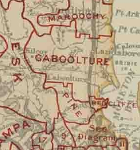
Originally part of the Caboolture Division — one of the seventy-four divisions created under the Divisional Boards Act 1879 — the 771 square kilometre Pine Division became a separate local government area in 1888 and existed until 2008, when it amalgamated with the City of Redcliffe and Caboolture Shire to form the Moreton Bay Region.
Under the Local Authorities Act 1902, Pine Division became the Shire of Pine, which underwent significant changes in 1921 and 1955, and was renamed the Shire of Pine Rivers in May 1959.
The Shire took its name from three rivers contained within it: the Pine River, which empties into Bramble Bay, and its tributaries, the North Pine River and South Pine River.
The Pine Rivers Shire contained the following suburbs and rural localities
Urban suburbs
Albany Creek
Arana Hills
Bray Park
Brendale
Eatons Hill
Everton Hills
Ferny Hills
Griffin
Kallangur
Lawnton
Mango Hill
Murrumba Downs
North Lakes
Petrie
Strathpine
Warner
Rural localities
Armstrong Creek
Bunya
Camp Mountain
Cashmere
Cedar Creek
Clear Mountain
Closeburn
Dakabin
Dayboro
Draper
Highvale
Jollys Lookout
Joyner
King Scrub
Kobble Creek
Kurwongbah
Laceys Creek
Mount Glorious
Mount Nebo
Mount Pleasant
Mount Samson
Ocean View
Rush Creek
Samford Valley
Samford Village
Samsonvale
Whiteside
Wights Mountain
Yugar
Sources:
- Apple Maps (Location)
- Queensland Places: Pine Rivers Shire
- Wikipedia: Pine Rivers Shire