Ravenshoe
Located 930 metres above sea level at the junction of the Kennedy and Palmerston Highways, 38 kilometres south of Atherton, 81 kilometres south-southwest of Cairns and 58 kilometres west-southwest of Innisfail on Dyirbalŋan country in the Tablelands Region, Ravenshoe is Queensland's highest town.
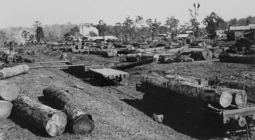
The area around Ravenshoe was first settled by pastoralists as the Evelyn and Woodleigh pastoral stations before 1881, when good stands of cedar were found at North and South Cedar Creeks. However, the area's timber resources remained unexploited until 1897, when the Irvinebank mining entrepreneur, John Moffat, acquired Evelyn station, imported sawmill equipment from Tasmania, and established the settlement initially called Cedar Creek.
With nearby Herberton connected by railway to Cairns in 1910, Cedar Creek was renamed Ravenshoe — supposedly because a survey party working to subdivide the area into dairy farms found a discarded copy of Henry Kingsley's novel Ravenshoe nearby.
By the start of World War I, Ravenshoe had a population of 1,000, supported by a timber industry based on cedar, Queensland maple, oak, and black walnut, as well as by dairying.
When the railway line, which had reached nearby Tumoulin in 1907, reached Ravenshoe in 1916, dairy produce was railed to the Golden Grove factory at Atherton. However, timber remained the main industry until 1987, when 900,000 hectares of surrounding rainforest received UNESCO World Heritage listing. Although the railway link to Atherton closed the following year, a section has been preserved with a historical steam train running from Queensland's highest town) to Queensland's highest railway station at Tumoulin..
Since then, Ravenshoe's main industries have been tourism — the nearby Millstream Falls are Australia's widest waterfall — and beef and dairy farming. The Innot Hot Springs have spa and pool facilities.