Herberton
Located on the Atherton Tableland in Dyirbalŋan Country, 16 kilometres southwest of Atherton, 65 kilometres southwest of Cairns and 70 kilometres west-northwest of Innisfail, Herberton is 918 metres above sea level on the Great Dividing Range.
James Venture Mulligan was looking for gold when he became the first European to explore this area in 1875, but he found tin. Guided by John Atherton, John Newell, who had been involved with tin mining around Stanthorpe, and William Jack, found the Great Northern tin lode in 1880. Newell named the town that developed around the lode — directly or indirectly — after Queensland's first premier. Herberton is on the Wild River — a tributary of the Herbert — and Newell may have named the town after the river or, possibly, the man. After George Elphinstone Dalrymple charted the stream in 1864, Surveyor-General Augustus Charles Gregory named it after Robert George Wyndham Herbert.
After mining began in May 1880, Newell and Jack's former employer, John Moffat, took charge and developed a mine that almost immediately yielded spectacular profits. Newell and Jack reversed their names and went into business, running a store that spawned a chain of businesses across North Queensland. By September, the town had a population of 300 men and 27 women. Herberton Post Office opened in November, followed by a Provisional School (December 1881) and a State School by January 1884. The school was one of the first five schools in Queensland to receive a secondary department in 1912.
In January 1882, the Queensland Government called for tenders to construct a telegraph line to Herberton.
The 1885 Post Office directory estimated Herberton's population at about 600, with a hospital, six stores, an assortment of other businesses, two banks, twelve hotels, and two newspapers — the Wild River Times and the Herberton Advertiser.
In the meantime, the road that would become the Mulligan Highway was carved through the hills, passing through the future sites of Atherton and Mareeba en route to Port Douglas. While Cobb and Co's coaches used the road to access centres in the hinterland, the area's tin mines needed a railway line to a coastal port. Three possibilities were considered: Geraldton (later, Innisfail) was closest, but the route passed through the roughest terrain. The route to Port Douglas was the easiest to build, but was the longest. Between the other two, Cairns had the best port..Since the Barron Gorge route's unstable geology was not known at the time, Cairns was selected. The first section of the railway from Cairns to Redlynch opened in October 1887, and the line eventually reached Herberton in October 1910. Although the tin mining boom was over by that time, the line continued to Tumoulin (July 1911) and Ravenshoe (December 1916).
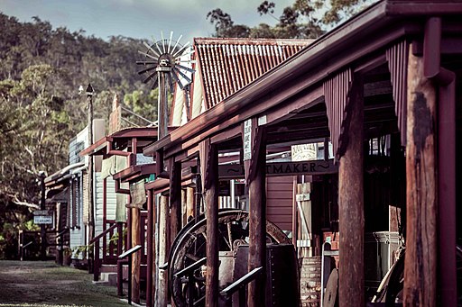
The town's population hovered between 900 and 1100 while mining and smelting continued, declined briefly after it stopped in 1978, then recovered in the 1990s as tourism became increasingly significant. A privately run historical village dating back to 1973 closed in 2003 but re-emerged as Herberton Historic Village with over fifty original buildings five years later.
The Wet Tropics' World Heritage Listing saw the railway line from Atherton to Ravenshoe closed in 1988. The section between Herberton and Tumoulin is still in use; the Ravenshoe Steam Railway operates heritage steam train tours along the route.